 UK Roads: London Inner Ring Road UK Roads: London Inner Ring Road
This list is as thorough as I can make it and takes into account all the many one-way sections. Where the route crosses the Thames it's indicated by  .
.
The information is taken from the Central London section of the AA 1998 Motoring Atlas of Britian, with corrections derived from Streetmap.
| Clockwise | |
|---|---|
| A501 | Pentonville Road, City Road |
| A5201 | Old Street |
| A10 | Shoreditch High Street |
| A1202 | Commercial Street |
| A11 | Whitechapel High Street, Braham Street |
| A1202 | Leman Street |
| A1210 | Prescot Street, Mansell Street |
| A100 | Tower Bridge Approach, Tower Bridge , Tower Bridge Road |
| A201 | New Kent Road |
| A3 | Elephant & Castle, Newington Butts |
| A3204 | Kennington Lane |
| A202 | Durham Street, Harleyford Road, South Lambeth Road, South Lambeth Place, Bridgefoot, Vauxhall Bridge , Bessborough Gardens |
| B301 (A3123) (!) | Drummond Gate, Bessborough Street, Belgrave Road, Eccleston Bridge, Eccleston Street |
| A3217 | Eaton Road, Hobart Place |
| A302 | Grosvenor Place, Hyde Park Corner |
| A4202 | Park Lane |
| A40 | Cumberland Gate, Marble Arch |
| A5 | Edgware Road |
| A501 | Chapel Street, Old Marylebone Road, Marylebone Road, Euston Road |
| Anti-Clockwise | |
| A501 | Euston Road, Marylebone Road, Old Marylebone Road |
| A5 | Edgware Road |
| A40 | Marble Arch |
| A4202 | Park Lane |
| A302 | Hyde Park Corner, Duke Of Wellington Place, Grosvenor Place, Lower Grosvenor Place, Bressenden Place, Victoria Street |
| A202 | Vauxhall Bridge Road, Bessborough Gardens, Vauxhall Bridge , Bridgefoot, Kennington Lane |
| A3204 | Kennington Lane |
| A3 | Newington Butts, Elephant & Castle |
| A201 | New Kent Road |
| A100 | Tower Bridge Road, Tower Bridge , Tower Bridge Approach, Minories |
| A1211 | Minories, Goodman's Yard |
| A1210 | Mansell Street |
| A11 | Whitechapel High Street |
| A1202 | Commercial Street, Great Eastern Street |
| A5201 | Old Street |
| A501 | City Road, Wakley Street, Goswell Road (A1), Pentonville Road, Penton Rise, King's Cross Road, Swinton Street, Gray's Inn Road, Pentonville Road |
UK Roads: History of London's Motorways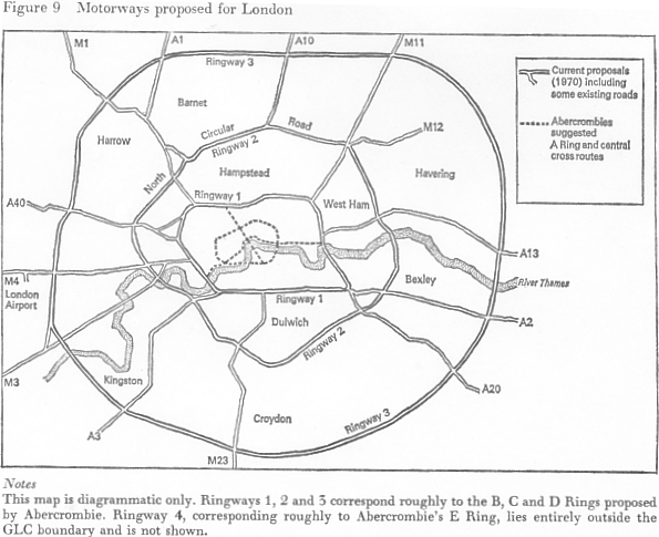
Fig. 9 from p. 85 of Towns Against Traffic by Stephen Plowden, published by André Deutsch Ltd., 1972.
Introduction
London has had ring road plans since the 1940s. What follows here is a potted history and explanation of the diagram above.
The caption text mentions Abercrombie and his plans. The following quote will suffice to explain the significance of that man's vision:
"Even before the war was over a regional planner, Patrick Abercrombie, had prepared two proposals, the County of London Plan and the Greater London Plan, which would lend London 'order and efficiency and beauty and spaciousness' with an end to 'violent competitive passion'. It is the eternal aspiration, or delusion, that somehow the city can be forced to change its nature by getting rid of all the elements by which it had previously thrived."
P. 755 of London: The Biography (paperback ed.) by Peter Ackroyd, published by Vintage, 2001.
I suggest you have a map of the Greater London area handy (most road atlases have a section just like this towards the back of the atlas). Before we begin, please accept my apologies for the hopeless bias against South London. But having grown up in Wanstead, and with my father's side of the family living in Bushey and Muswell Hill, and my mother's side living in Maidstone, the M25 and North Circular were the well-travelled roads of choice for weekend visits. But enough of my childhood.
A glance at the diagram shows that all the radial roads are still in existence, with the exception of the M12 which is still the A12 of course. Then we have the Ringways: heavens, they had ambitious plans back then! Let's take a detailed look at each in turn...
Ringway 1 (Inner)
This is the fabled London Box plan of yesteryear. Only small fractions were actually ever built, and those are essentially the north-west and north-east corners, as follows: The Westway, the elevated section of the A40, formerly the A40(M), that runs between Wood Lane and Marylebone Road; The West Cross Route, the A3220, formerly the M41, a tiny section of urban motorway running between the Westway and Shepherds Bush; The Eastway, the A12, formerly the A102(M), at Hackney Wick; lastly, the East Cross Route, which is the A102, formerly suffixed with an (M), which runs south from the Eastway, across the A11 at Bow, and through the Blackwall Tunnels to connect up with the A2 at Kidbrooke south of the Thames. The fact that these four small sections were motorways (they were downgraded in 2000) shows the adherence to the original plan, and the scope of its design. However they also betray its ambitions, which were grandiose even in the motor-car-fixated concrete-happy 1970s! It's difficult to see how the West Cross Route could have been extended south without the destruction of parts of Earl's Court and Fulham! Anyway, that wraps up the east and west sides.
I presume the upgrading of the present A501 Marylebone, Euston and Pentonville Roads would have been the logical continuation of the Westway. Indeed, there are underpasses along those roads, which today make up the northern part of the Inner Ring Road (see above). Exactly where the urban motorway would have gone east of The Angel, though, is anyone's guess. All I can imagine is a route along the lines of the A104 and A102 through Dalston and Homerton, to connect up with the Eastway of course. Although never the most prosperous parts of London, those areas are slowly becoming fashionable (look at Hoxton and Shoreditch). Keep in mind, though, that this plan was mooted around 1970 when even Islington was a bit slummy, so I suppose the vision of a new motorway through these areas wouldn't have been as incredulous as it appears now.
South of the river, I've not a clue where the road would have gone, but then is it any wonder when the North Circular (see below) is virtually all grade-separated dual carriageway, and the South Circular is still a nightmare of high streets? There's obviously something about South London, and its topography does come into it, that the transport planners have always been blind to. There are some notable exceptions of course: the Croydon tram springs to mind.
Ringway 2 (Intermediate)
Ah, the north bit is easy: it corresponds to the lovable A406 North Circular Road, as it states on the diagram. This is now all grade-separated dual carriageway between the A13 and the A40, except for a small section at Bounds Green (Bowes Road) which is still single carriageway. Between the A40 and the M4, which is Hanger Lane and Gunnersbury Avenue, the A406 is single carriageway. To the west, the Circular Road crosses the Thames at Kew Bridge. To the east, there is still a proposed river crossing between Beckton and Plumstead, although it looks likely that it will connect to the A2 rather than the South Circular. The Woolwich Ferry is still used to make the connection between the North and South Circulars near this point. However I'm certain the vast majority of drivers make the trip through the Blackwall Tunnels and use the A13 to connect up rather than take the ferry. In which case, Ringway 2's traffic is still bottlenecking through Ringway 1's river crossing over thirty years later!
The South Circular Road, the A205, would correspond to the section south of the Thames. Again, much liberty has been taken with the plan here. It's easy to draw a line on a map, but much, much more difficult to actually integrate a proposed motorway into existing roads and streets without some serious outlay.
Ringway 3 (Outer)
This corresponds to what would eventually become the M25 London Orbital Motorway. The first section of the M25 was a stretch through Epping Forest, between South Mimms and Waltham Abbey, and this was initially numbered the M16. The M25 derives its number from the A25, which it roughly parallels in Surrey and Kent. You'll notice that on the diagram 'London Airport', Heathrow of course, lies outside the western section of Ringway 3. In fact the M25 circumscribes a far more generous arc of Greater London than originally planned, given Heathrow now lies within its circumference. Therefore, the A312 fits in better with the diagram along the western edge of the conurbation. In fact the section between the M4 and the A40, The Parkway (or Hayes Relief Road), was finished to a high standard in the mid 1990s so it must have been recognised as an important distributor. This leads me onto...Ringway 4 (Orbital)
This outermost section just shows how big the planners were originally thinking. You can actually trace the path of the road through Middlesex very easily as the North Orbital Road is still named as such (try looking it up in the index of a London A-Z or on Streetmap). That is, the A412 north of Uxbridge and passing through Rickmansworth, Croxley and Watford, and from there the A405 through Bricket Wood to the semi-legendary Park Street Roundabout, are the existing parts of the North Orbital Road. It is unclear exactly where the road would have gone from here (it's beyond the boundary of the diagram), but the A414 has long been an unofficial north-of-London bypass and indeed it has primary status.Once again, where an orbital road this far out south of the Thames would have run is anyone's guess and I should think we'll never know. Certainly we'll never ever see it!
Road Building and Politics
Just contrast Ringways 1 & 2 with what happened to Paris in the 1970s. The notorious Périphérique was built: a complete intermediate orbital urban motorway. It may be busy and dangerous (in truth, that's more to do with Parisian drivers than the tight curves), but it has proved utterly necessary. Now the similarities with London break down in at least two major places. Firstly there was, and still is, the strong central government of France (socialism works!). Secondly there's the geography of Paris: the road runs round the outside of the old city walls (this is why the sorties are all called portes), an area traditionally light on development. Having said that though, this just shows up not the lack of vision, but the lack of committment to see a plan through that the British have always produced in spades. Much to our detriment. In some ways, of course, this is due to factors such as our public consulations on, and right to object to, road schemes. Some would proclaim this as a Good Thing. I, however, would not. And given as how long the CTRL is taking to emerge, for example, I feel justified in that claim. It seems (major) road building and politics, especially in urban areas, are inextricably linked. Let's see what Ken has up his sleeve for London, and Londoners.
Further Reading
May I suggest Towns Against Traffic by Stephen Plowden, published by André Deutsch Ltd., 1972. Contrast that with Traffic in Towns (aka the Buchanan Report), published by the HMSO, 1963. The latter includes a case study of London's Oxford Street, which nigh on forty years later looks insane. For starters note the difference in titles and years of publication: by the tail end of the 1960s the tide against roads, specifically urban motorways, had already started to turn...
Paul Berry, 5-7th Apr 02

