UK Roads - Road Trips - Mam Tor
A625/A625: Sheffield (A621) - Calver Crossroads (A623)
Bob Sykes originally wrote this entry on the A625:
Formerly went to Chapel-en-le-Frith – a bit of a 'hub' for the A620s! Until it was re-routed a couple of years ago, this road had the unique distinction of having 'a bit missing' from its western section at Mam Tor in the Peak District. Not because of re-numbering, or sharing its route with another road, but because the road collapsed, I think in the early 80s [Paul Berry: 1979 to be exact], due to massive subsidence, which couldn't be remedied at a realistic cost – so the A625 just ended in the middle of nowhere, and then restarted half a mile further along. There were two diversions, one a long winding B-road (now unclassified) through Edale (the village where the Pennine Way starts), the other a short unclassified single-track road down the Wynatts Pass, where the A625 resumed through Castleton and on to Sheffield via Hathersage. The collapsed section is still there untouched, with 'ripple-effect' surface, white lines, catseyes etc, and used only by walkers and bikers – worth a look if you're up there, as I guess its pretty unique. Most of this original route was renumbered recently, no doubt because of the missing bit. The Chapel to Mam Tor section is now an unclassified road, the Castleton – Hathersage section now the catchily-numbered A6187. Only the bit east of Hathersage into Sheffield remains A625, with the former B6054 and B6001 combo down to the A623 at Calver Cross now taking the A625 number for no obvious reason.
Update: 11th Apr 02 (revised 19th Sep 04)
The part of the road in question is half a mile west of Castleton. This is a 25-30 minute walk from the bus terminus, through the village and out the other side towards the famous Caverns. Approaching the Caverns, the road forks in two, which is also where the A-road status ends according to the map: left is Winnats Pass, right is Mam Tor. Early indications that the road is no longer a through route are the parking spaces all the way down alternate sides of the road. The council took succinct advantage of the failed road: it's essentially a very long car park. Just as well since there's nowhere else to park for visitors to the Caverns. Another pointer is the sign for a 'Coach turning circle 3/4 mile ahead'. That turning circle is a far as most traffic is allowed to go and is next to a piece of NT land known as Odin's Mines.
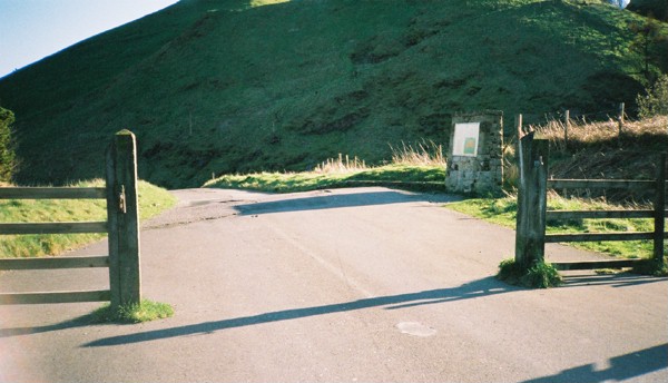
The restricted part of the road is in two sections: the first part, the lower road, has been much repaired and patched over, and it provides access to Mam Farm. The upper road is fenced off to vehicular traffic and you enter on foot or bike by a gate. There's a very good reason for this part to be closed and you'll see why later!
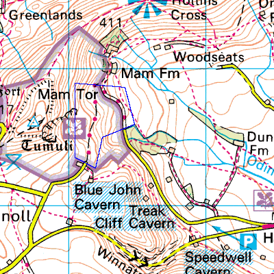
For your reference, on Streetmap, you can see the general location and the specific view.
OK, here's the good stuff. I took these photos between about 17:30 and 18:00 that day, hence the long shadows. A map of the area under review, bound by a blue box, is shown below:
|
|
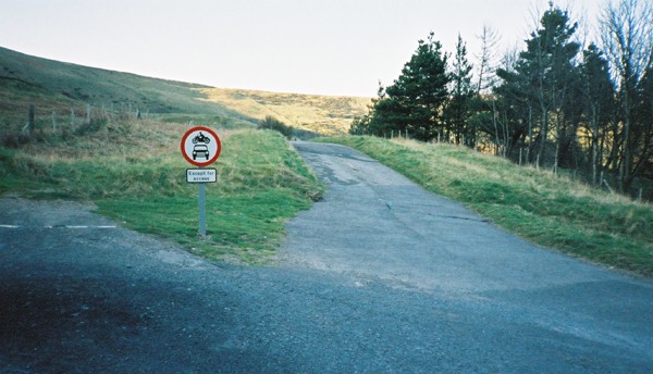
1. The beginning of the restriction. Note the plate reads 'Except for access' so motor traffic is still permitted past this point. Indeed I noticed two cars going for a spin as I was taking notes. The road is narrowed to one lane here, the downhill one being grassed over. The turning circle is off to the right. |
|
|
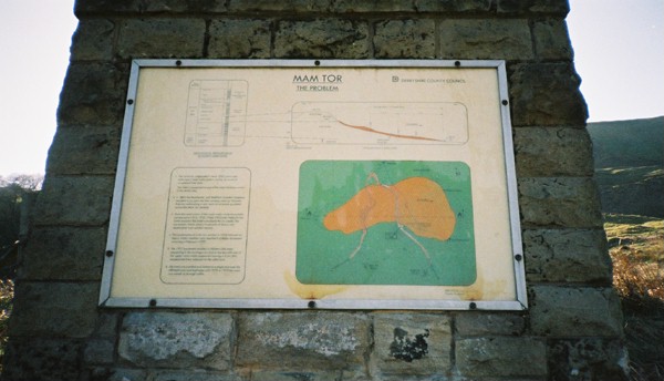
2. A little further along on the left is this information plaque erected by Derbyshire CC. Clockwise from top left there's a diagram of a vertical section of the rock strata; a cross-section of the hillside (landslip material is in orange), a plan of the road, which follows an inverted V shape; and some explanatory text, which is reproduced here. |
|
|
3. We're looking back for a moment now. There was once a gate across the road. You can just make out the centre line. Note also the cateyes have been filled in, elsewhere they've merely been removed. Off to the right, water has collected and is retained by the raised carriageway, thus forming a pond. |
|
|
4. Stress fractures in the pavement. Cracks like this, extending the full depth of the tarmac, are legion. Note the attempts made to patch the split. It has since reappeared just to the right of where it was. Just off to top-right, at the edge of the carriageway, is an original white cast-iron milestone, a sketch of which is reproduced below.
|
|
|
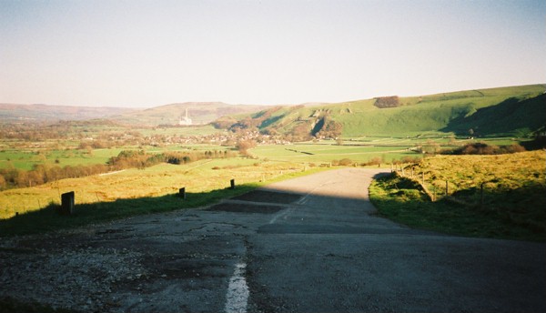
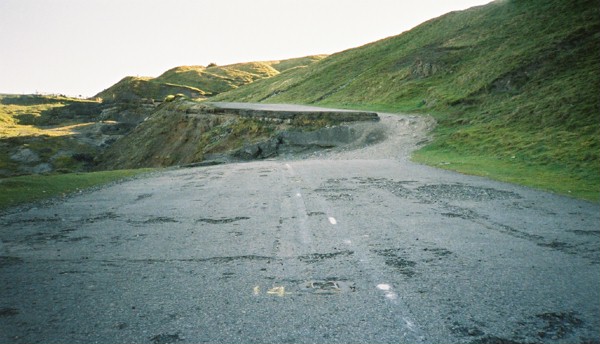
5. A little further on and the road levels out for a short stretch. We're facing back along the Hope Valley to capture a view. Castleton is in the distance, with the dark hollow of Cavedale to the right in the hillside. The chimney of the Blue Circle cement works at Hope is in the far background. Note the extensive patching on the road, and the worn-out surface. The line markings are clearer on this section. We're just in the shadow or Mam Tor at this point. |
|
|
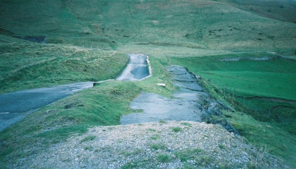
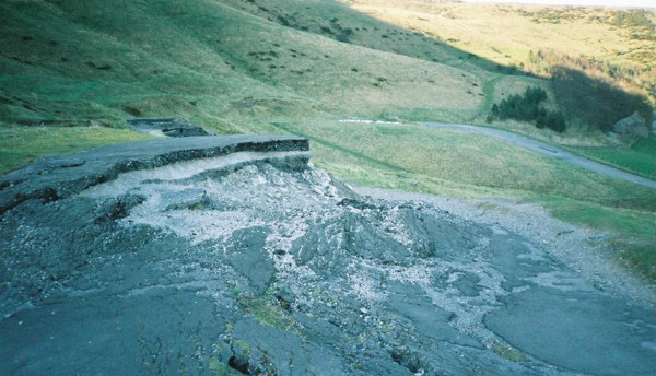
6. Here's the first view of how extensive and devastating the landslide was. The downhill lane has simply fallen away. You can see the road was shored up with heavy timbers and reduced to one lane. Even then it had to be extensively patched and resurfaced in places. Remember the road is still offically operational along this section! |
|
|
7. We're now on the fenced-off part of the road. No need to explain why this isn't for cars! Just in front of us is a 2 foot drop in the pavement, and condsiderable ruptures in the surface unfold ahead of us. As you might imagine, this section of the road is very popular with mountain bikers. |
|
|
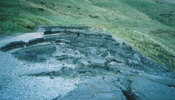
8. Looking back at the step, you can see a neat cross-section of the rock the road was built on. The carrigeway is clearly utterly beyond repair. |
|
|
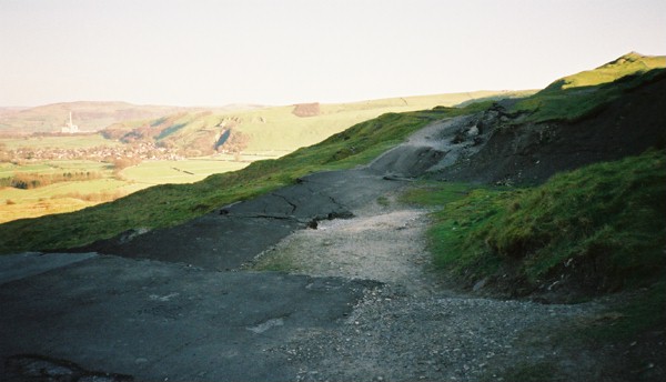
9. Facing downhill still, there's more devastation, with great cliffs of tarmac showing the former level of the pavement. You can see Mam Farm to the right. Straight ahead, where the light-coloured rubble on the outside of the bend is, is the gate across the road. |
|
|
10. Looking back up to the summit of the road we see another axle-never-mind-leg-breaking rift in the carriageway. Note the road markings just here: there's evidence of a change to the centre line, as the road had effectively been narrowed by loss of the uphill lane behind us. Futhermore you can see the catseyes had been numbered, and subsequently removed. |
Please send me your corrections or additions to this page.